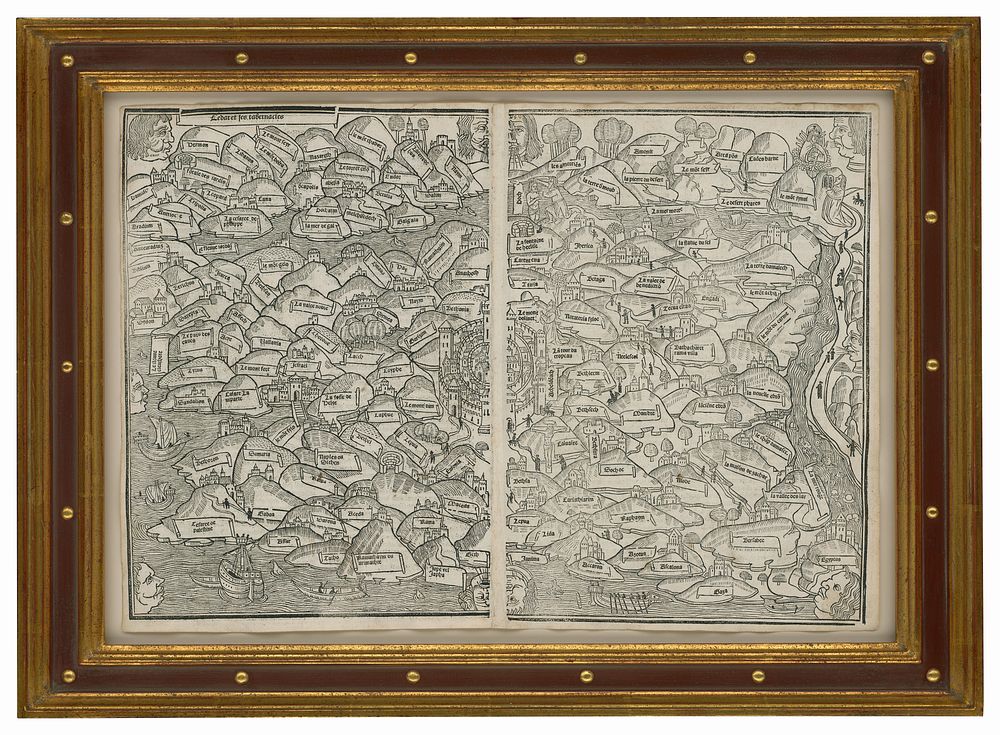
Bidspirit auction | ANONYMOUS. Untitled Woodcut Map of
ANONYMOUS. Untitled Woodcut Map of the Holy Land. A SUPERB EXAMPLE. Fine condition with complete margins. Two joined sheets. 12 x 17 5/8 inches. Finely framed. T. Campbell, The Earliest Printed Maps, no. 218, pp. 144-51; cf. Nebenzahl, Maps of the Holy Land, p. 62. [Lyons, 1506]. ”THE EARLIEST MODERN PRINTED MAP” - Campbell. In its first edition of 1475 (Lubeck), this was, as Campbell states, the first modern printed map in the sense of being the first printed work to attempt something approaching a realistic geographic depiction of an area. It preceded by two years the first edition of the Ptolemy atlas of Bologna, which was the first atlas overall. Previous to this, printed maps were limited to diagrams or works based more on theology than geography. This first edition of this map referred to above is, practically speaking, unacquirable. Only a single, complete copy has appeared on the market in the last 25 years (it now resides in the Osher Map Library, Portland, Maine). However, new editions of this map and an accompanying world map, closely modeled after the Lubeck editions, were published first in Paris in 1488 and then in Lyons in 1491. Our 1506 example is the second Lyons edition. There were at least four later Lyons editions through 1555. (Examples of the maps from particular editions can be readily differentiated, as indicated by Campbell.) In recent years, only editions of 1517 or later have appeared on the market and usually in poor, trimmed examples. Thus, this 1506 edition is one of the earliest editions of this map to become available in several years and is especially desirable for its unusually fine condition. According to Nebenzahl, the map was based on a lost work by Burchard of Mt. Sion, a 13th century Dominican from Magdeburg, who made the map to illustrate his pilgrimage to the Holy Land. With east at the top, the map displays the Holy Land from Damascus and Sidon in the north to the Red Sea in a kind of modified, very high-altitude bird's-eye view. In stylized fashion, each town and city is shown atop a separate mountain separated by walls or rivers. A compact Jerusalem with its several walls is at the very center of the map. In this edition, the place names were changed to French from the Latin of the Lubeck edition. The map appeared in a work entitled La Mer des histoires, a history of the world up to the year 1475, which also contained a geographical summary. The maps of the Holy Land that would soon be published after this one in the many editions of the Ptolemy atlas, were not based on the prototype used by this map. Thus, its highly distinctive visual manner, so redolent of its medieval source, yet still taking a step toward modern mapping, is available to the collector only in the various editions of this map itself.