Bidspirit auction | Linschoten - Map of the
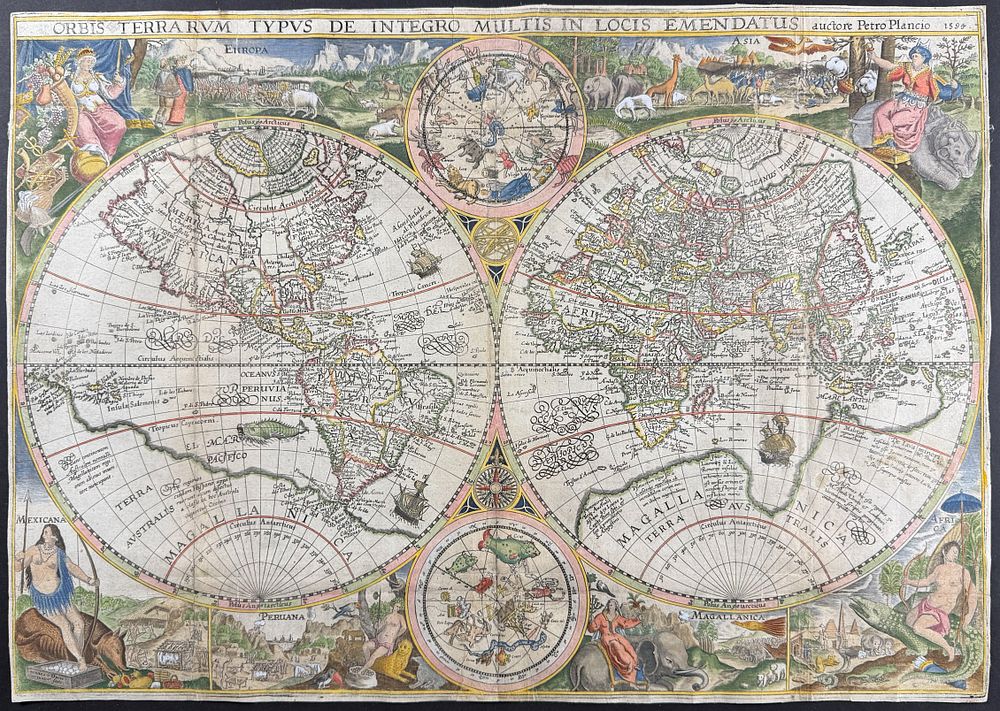
Linschoten - Map of the World by Petrus Plancius [Orbis Terrarum Typus De Integro Multis In Locis Emendatus auctore Petro Plancio 1594] - About the map: This stunning world map was created by Petrus Plancius in 1594. It was originally issued on its own, but would begin being published with Linschoten's works beginning in 1599. Plancius drew inspiration for his map from the Gerard Mercator's world map of 1587. The engraving was done by the Dutch master, Jan van Doetecum. Plancius's map was the first printed map to include decorative allegorical figures in the borders. These figures represented the major regions of the known world including: Europa, Asia, Africa, Magallanica, Peruana, and Mexicana. These illustrations were inspired by the works of Theodor de Bry. His mapping of the Arctic and Far East were of particular note in this example due to his work with merchants and navigators of the time. It is also the first time Korea appears as a peninsula on a map rather than an island. Sea Monsters and ships decorate the oceans. Smaller spheres featuring the Northern and Southern celestial skies / constellation are included. The map included a southern contient labeled 'Magallanica' which was based upon the continental balance theory and often called 'Terra Australis Incognita' before the discovery of Antarctica. It includes New Guinea and part of Java in connection to the southern continent. Petrus Plancius [Pieter Platevoet] (1552-1622) was a Dutch theologian, cartographer, and astronomer. He was one of the founders and the geographers for the Dutch East India Company (VOC). About the work: This exceptionally detailed, important engraving is from Jan Huygen van Linschoten's Histoire de la Navigation aux Indes Orientales... Le Grand Routier de Mer... Description de l'Amerique or Navigatio ac Itinerarium Iohannis Hugonis Linscotani in Orientalem Sive Lusitanorum Indiam... [Voyage and Journey of Jan Huygen van Linschoten to the Eastern, or Portuguese India...] commonly referred to as Itinerarium . The work was published in Amsterdam in 1619 by Jan Everts Cloppenburgh. This is from the second French edition of the work. Jan Huygen van Linschoten (1563-1611) was a Dutch spy, merchant, traveler, and writier. This work detailed Linschoten's time in Portuguese Goa under the employ of the Viceroy. He was immersed in the culture of the East and learned about trade opportunities with China, Japan, and the Spice Islands. His gathering of classified information allowed the Dutch and later English to break the Portuguese trade monopoly in the East. Provenance: Philadelphia Mercantile Library ink stamp to verso of first title Paper Size: ~ 23” by 16 1/4” (Fold Out) Paper Type or Special Features: Engraving with Professional Hand-coloring